
Datei:Bang Kachao Landsat.jpg
Bang_Kachao_Landsat.jpg (720 × 480 Pixel, Dateigröße: 246 KB, MIME-Typ: image/jpeg)
Beschreibung
| Beschreibung |
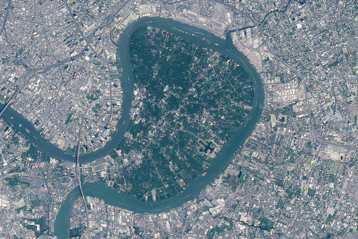
English: In the heart of Thailand’s most populous city, an oasis stands out from the urban landscape like a great “green lung.” That’s the nickname given to Bang Kachao—a lush protected area that has escaped the dense development seen elsewhere in Bangkok.
The city is built on the alluvial plain of the Chao Phraya River. Toward the southern end, near the Gulf of Thailand, is an old meander that never quite formed an oxbow lake. That meander traces the boundary of Bang Kachao, which TIME magazine once called the “best urban oasis” in Asia. On February 2, 2014, the Operational Land Imager (OLI) on Landsat 8 captured this natural-color view of Bang Kachao (also called Bang Krachao or Bang Kra Jao). The top image is a close up view of the region outlined with a rectangle in the bottom image. Bang Kachao is actually an island—albeit an artificial one. The Klong Lad Pho canal, built at the neck of the oxbow, allows water from the Chao Phraya to more quickly reach the sea. The canal contains floodgates that control water levels to prevent flooding. Immediately west of the canal is the Bhumibol Bridge, which twice crosses the Chao Phraya River. Look east of the mid-bridge interchange, however, and a stark transition occurs, as the urban jungle gives way to about 2,000 hectares of rural jungle, villages, and farmland. According to a travel story in The New York Times, Bang Kachao is gaining popularity among tourists lured by bike tours, a floating farmers’ market, and the relaxed atmosphere.[1] |
| Datum | |
| Quelle | http://earthobservatory.nasa.gov/blogs/earthmatters/2015/03/03/february-puzzler-answer-bang-kachao/ |
| Urheber | NASA Earth Observatory image by Jesse Allen, using Landsat data from the U.S. Geological Survey. |
Lizenz
| Diese Datei ist gemeinfrei (public domain), da sie von der NASA erstellt worden ist. Die NASA-Urheberrechtsrichtlinie besagt, dass „NASA-Material nicht durch Urheberrecht geschützt ist, wenn es nicht anders angegeben ist“. (NASA-Urheberrechtsrichtlinie-Seite oder JPL Image Use Policy). | ||
 |
Warnung:
|
Dateiversionen
Klicke auf einen Zeitpunkt, um diese Version zu laden.
| Version vom | Vorschaubild | Maße | Benutzer | Kommentar | |
|---|---|---|---|---|---|
| aktuell | 14:39, 3. Mai 2016 | | 720 × 480 (246 KB) | Paul 012 | {{Information |Description ={{en|1=In the heart of Thailand’s most populous city, an oasis stands out from the urban landscape like a great “green lung.” That’s the nickname given to Bang Kachao—a lush protected area that has escaped the d... |
Dateiverwendung
Die folgende Seite verwendet diese Datei:
Globale Dateiverwendung
Die nachfolgenden anderen Wikis verwenden diese Datei:
- Verwendung auf de.wikipedia.org
- Verwendung auf en.wikipedia.org
- Verwendung auf th.wikipedia.org
- Verwendung auf uk.wikipedia.org