
Datei:Gilgit-Baltistan map with tehsils labelled.png

Größe dieser Vorschau: 800 × 399 Pixel. Weitere Auflösungen: 320 × 160 Pixel | 640 × 319 Pixel | 1.024 × 511 Pixel | 1.280 × 639 Pixel | 2.560 × 1.278 Pixel | 8.058 × 4.022 Pixel.
Originaldatei (8.058 × 4.022 Pixel, Dateigröße: 1,47 MB, MIME-Typ: image/png)
Beschreibung
| Beschreibung |
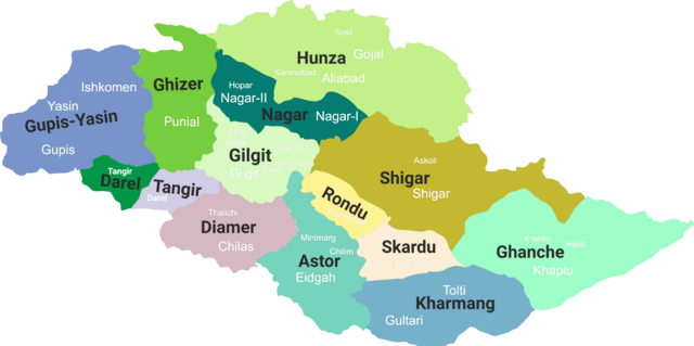
English: Gilgit-Baltistan map with tehsils labelled |
| Datum | (updated 2019) |
| Quelle | Eigenes Werk |
| Urheber | Kazmi |
Lizenz
Ich, der Urheber dieses Werkes, veröffentliche es unter der folgenden Lizenz:
Diese Datei ist lizenziert unter der Creative-Commons-Lizenz „Namensnennung – Weitergabe unter gleichen Bedingungen 4.0 international“.
- Dieses Werk darf von dir
- verbreitet werden – vervielfältigt, verbreitet und öffentlich zugänglich gemacht werden
- neu zusammengestellt werden – abgewandelt und bearbeitet werden
- Zu den folgenden Bedingungen:
- Namensnennung – Du musst angemessene Urheber- und Rechteangaben machen, einen Link zur Lizenz beifügen und angeben, ob Änderungen vorgenommen wurden. Diese Angaben dürfen in jeder angemessenen Art und Weise gemacht werden, allerdings nicht so, dass der Eindruck entsteht, der Lizenzgeber unterstütze gerade dich oder deine Nutzung besonders.
- Weitergabe unter gleichen Bedingungen – Wenn du das Material wiedermischst, transformierst oder darauf aufbaust, musst du deine Beiträge unter der gleichen oder einer kompatiblen Lizenz wie das Original verbreiten.
Dateiversionen
Klicke auf einen Zeitpunkt, um diese Version zu laden.
| Version vom | Vorschaubild | Maße | Benutzer | Kommentar | |
|---|---|---|---|---|---|
| aktuell | 12:14, 19. Jun. 2019 | | 8.058 × 4.022 (1,47 MB) | Kazmi | Added missing details - district Tangir and Darel - Added names of main localities |
| 03:19, 19. Jun. 2019 |  | 8.058 × 4.022 (1,36 MB) | Kazmi | Added names and redefined the boundaries of newly established districts | |
| 03:50, 28. Jun. 2017 |  | 1.952 × 997 (80 KB) | Kazmi | User created page with UploadWizard |
Dateiverwendung
Die folgende Seite verwendet diese Datei:
Globale Dateiverwendung
Die nachfolgenden anderen Wikis verwenden diese Datei:
- Verwendung auf bn.wikipedia.org
- Verwendung auf en.wikipedia.org
- Masherbrum
- Kanjut Sar
- Haramosh Peak
- Distaghil Sar
- Chogolisa
- Districts of Pakistan
- Zarabod
- Sust
- Gilgit Agency
- Gasherbrum III
- Gasherbrum IV
- Baintha Brakk
- Hispar Muztagh
- Batbaykor
- Diran
- Kunyang Chhish
- Shispare
- Batura Sar
- Malubiting
- K6 (mountain)
- Shigar River
- Astore Wildlife Sanctuary
- Baltistan Wildlife Sanctuary
- Laila Peak (Haramosh Valley)
- Laila Peak (Rupal Valley)
- Passu Sar
- Taghafari
- Snow Dome, Concordia
- Rakaposhi-Haramosh Mountains
- Askole
- Panmah Muztagh
- Hispar Glacier
- Astore Valley
- Ghanche District
- Skardu District
- Gilgit District
- Diamer District
Weitere globale Verwendungen dieser Datei anschauen.