
Datei:NintokuTomb Aerial photograph 2007.jpg
Größe dieser Vorschau: 610 × 599 Pixel. Weitere Auflösungen: 244 × 240 Pixel | 489 × 480 Pixel | 1.000 × 982 Pixel.
Originaldatei (1.000 × 982 Pixel, Dateigröße: 1,82 MB, MIME-Typ: image/jpeg)
Beschreibung
| Beschreibung |
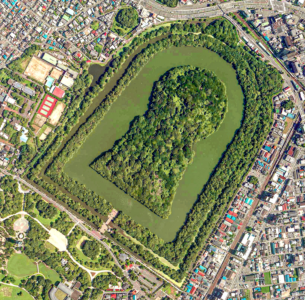
日本語: 大阪府堺市堺区大仙町にある大仙陵古墳の空中写真。世界最大級の墳墓で宮内庁により仁徳天皇の陵墓に治定されている。「百舌鳥・古市古墳群」を構成する資産の一部として世界文化遺産に登録されている。
国土地理院の航空写真CKK20071-C55A-10から、Naokijpが作成。
English: Daisen-Kofun is the tomb of Emperor Nintoku in Sakai, Osaka, Japan. This is one of the largest tombs in the world. The keyhole-like tomb is 486m long, 305m wide at the bottom and 245m in diameter.
Español: El Daisen-Kofun, tumba legendaria de Emperador Nintoku
Suomi: Kofun-kauden hautakumpu Osakassa, yksi maailman suurimmista. |
| Datum | |
| Quelle |
English: Ministry of Land, Infrastructure, Transport and Tourism Geospatial Information Authority of Japan Map/aerial photo browsing service 日本語: 国土交通省 国土地理院 地図・空中写真閲覧サービス (https://mapps.gsi.go.jp/maplibSearch.do#1) |
| Urheber |
English: Geospatial Information Authority of Japan 日本語: 国土地理院 |
Lizenz

|
Der Urheberrechtsinhaber dieser Datei, Ministerium für Land, Infrastruktur, Verkehr und Tourismus, erlaubt es jedem, diese für jeden Zweck zu benutzen, vorausgesetzt, dass der Urheberrechtsinhaber ordnungsgemäß genannt wird. Weiterverbreitung, Abänderungen, kommerzielle Nutzung sowie jede andere Verwendung sind gestattet. |
Namensnennung:
Copyright © National Land Image Information (Color Aerial Photographs), Ministry of Land, Infrastructure, Transport and Tourism
|
 |
This image is copyrighted by the Ministry of Land, Infrastructure, Transport and Tourism of Japan. For terms of use, see the stipulation to use of National Land Information (in Japanese) and message from MLIT (in Japanese and English). When you display this image on an article, include the following phrase in the description: "Made based on National Land Image Information (Color Aerial Photographs), Ministry of Land, Infrastructure, Transport and Tourism".
|
Dateiversionen
Klicke auf einen Zeitpunkt, um diese Version zu laden.
| Version vom | Vorschaubild | Maße | Benutzer | Kommentar | |
|---|---|---|---|---|---|
| aktuell | 15:52, 21. Jul. 2022 | | 1.000 × 982 (1,82 MB) | Naokijp | 彩度など微調整 |
| 07:06, 19. Jul. 2022 |  | 1.000 × 982 (1,7 MB) | Naokijp | Uploaded a work by 国土地理院 from 国土情報ウェブマッピングシステム with UploadWizard |
Dateiverwendung
Die folgenden 2 Seiten verwenden diese Datei:
Globale Dateiverwendung
Die nachfolgenden anderen Wikis verwenden diese Datei:
- Verwendung auf af.wikipedia.org
- Verwendung auf ar.wikipedia.org
- Verwendung auf ast.wikipedia.org
- Verwendung auf azb.wikipedia.org
- Verwendung auf az.wikipedia.org
- Verwendung auf be.wikipedia.org
- Verwendung auf bn.wikipedia.org
- Verwendung auf ca.wikipedia.org
- Verwendung auf ckb.wikipedia.org
- Verwendung auf cs.wikipedia.org
- Verwendung auf cy.wikipedia.org
- Verwendung auf da.wikipedia.org
- Verwendung auf de.wikipedia.org
- Verwendung auf el.wikipedia.org
- Verwendung auf en.wikipedia.org
Weitere globale Verwendungen dieser Datei anschauen.