
Datei:Aeolian Islands.jpg

Größe dieser Vorschau: 396 × 599 Pixel. Weitere Auflösungen: 159 × 240 Pixel | 317 × 480 Pixel | 508 × 768 Pixel | 677 × 1.024 Pixel | 2.032 × 3.072 Pixel.
Originaldatei (2.032 × 3.072 Pixel, Dateigröße: 610 KB, MIME-Typ: image/jpeg)
Beschreibung
| Beschreibung |
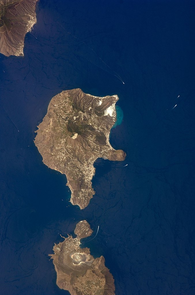
English: This detailed astronaut photograph features Lipari Island and the northern portion of Vulcano Island. Tan, speckled areas on both islands are urban areas and towns. Lipari is the largest of the Aeolian Islands, and it is a popular tourist destination due to its rugged volcanic topography and beaches (several boat wakes are visible around the islands). White pumice beaches and caves are located along the northern and northeastern coastlines of Lipari; black sand beaches derived from lava flows can also be found on the island. The most recent eruptive activity on Lipari took place from approximately AD 580–729.
|
||||||||||||||||||||||||||||||||||||||||||||||||||
| Datum | |||||||||||||||||||||||||||||||||||||||||||||||||||
| Quelle | NASA Earth Observatory | ||||||||||||||||||||||||||||||||||||||||||||||||||
| Urheber | This image was taken by the NASA Expedition 17 crew. | ||||||||||||||||||||||||||||||||||||||||||||||||||
| Kameraposition | | Dieses und weitere Bilder auf OpenStreetMap |
|---|
Diese Mediendatei wurde vom Johnson Space Center der US-amerikanischen National Aeronautics and Space Administration (NASA) unter der Datei-ID ISS017-E-9777 kategorisiert. Diese Markierung zeigt nicht den Urheberrechtsstatus des zugehörigen Werks an. Es ist in jedem Falle zusätzlich eine normale Lizenzvorlage erforderlich. Siehe Commons:Lizenzen für weitere Informationen. Sprachen:
|
This photograph was acquired with a Nikon D2Xs digital camera fitted with a 400 mm lens, and is provided by the ISS Crew Earth Observations experiment and the Image Science & Analysis Laboratory, Johnson Space Center.
Lizenz
| Diese Datei ist gemeinfrei (public domain), da sie von der NASA erstellt worden ist. Die NASA-Urheberrechtsrichtlinie besagt, dass „NASA-Material nicht durch Urheberrecht geschützt ist, wenn es nicht anders angegeben ist“. (NASA-Urheberrechtsrichtlinie-Seite oder JPL Image Use Policy). | ||
 |
Warnung:
|
Dateiversionen
Klicke auf einen Zeitpunkt, um diese Version zu laden.
| Version vom | Vorschaubild | Maße | Benutzer | Kommentar | |
|---|---|---|---|---|---|
| aktuell | 03:45, 15. Nov. 2013 | | 2.032 × 3.072 (610 KB) | Rotatebot | Bot: Image rotated by 90° |
| 19:07, 4. Mai 2011 |  | 3.072 × 2.039 (555 KB) | Originalwana | higher res | |
| 18:23, 23. Mai 2009 |  | 939 × 586 (115 KB) | Originalwana | {{Information |Description={{en|1=This detailed astronaut photograph features Lipari Island and the northern portion of Vulcano Island. Tan, speckled areas on both islands are urban areas and towns. Lipari is the largest of the Aeolian Islands, and it is |
Dateiverwendung
Die folgenden 2 Seiten verwenden diese Datei:
Globale Dateiverwendung
Die nachfolgenden anderen Wikis verwenden diese Datei:
- Verwendung auf ar.wikipedia.org
- Verwendung auf ast.wikipedia.org
- Verwendung auf ca.wikipedia.org
- Verwendung auf ceb.wikipedia.org
- Verwendung auf cy.wikipedia.org
- Verwendung auf el.wikipedia.org
- Verwendung auf en.wikipedia.org
- Verwendung auf en.wikivoyage.org
- Verwendung auf es.wikipedia.org
- Verwendung auf eu.wikipedia.org
- Verwendung auf fr.wikivoyage.org
- Verwendung auf gl.wikipedia.org
- Verwendung auf he.wikivoyage.org
- Verwendung auf hr.wikipedia.org
- Verwendung auf id.wikipedia.org
- Verwendung auf it.wikipedia.org
- Verwendung auf ko.wikipedia.org
- Verwendung auf lb.wikipedia.org
- Verwendung auf nl.wikipedia.org
- Verwendung auf ro.wikipedia.org
- Verwendung auf sl.wikipedia.org
- Verwendung auf www.wikidata.org
- Verwendung auf zh-yue.wikipedia.org
- Verwendung auf zh.wikipedia.org